7075
Uttrakhand
Pro
18
45
Itinerary
Day 1 :
Uttarkashi (1,160M) to Gangotri (3,415M)
Distance: 100 km DriveThe trek begins from Gangotri which is a mountain city on the banks of River Bhagirathi and is known to be the origin of the holy River Ganga. Located in the Greater Himalayan Range, legend says that this is where Goddess Ganga descended when Lord Shiva released the river from the locks of his hair. This holy city which lies at an altitude of 3,415M is a 100 km drive away from Uttarkashi.If you have signed up with Bikat for a drive from Dehradun to Gangotri, the day starts early. Everyone assembles at the meeting point by 7 in the morning so we can start our long drive up to Gangotri, a holy mountain city in the Uttarkashi district of Uttarakhand. Although there’s nothing more on the agenda for today other than the 5 hour drive, it is better to leave as early as possible for two reasons:One, so we can reach as early as possible and give our bodies enough rest for what’s coming the next day. And, two, roads on the mountains are unpredictable. It is always better to account for delays when we start. It is also better to reach before it gets dark.
Day 2 :
Acclimatization in Gangotri
Day two is reserved for rest and for acclimatization to the altitude. This is important to allow your body to adapt to its new environment and reduce chances of adverse health conditions. You can go around and explore the market, delve into the colors and culture of this high-mountain town and visit some places nearby. A little movement around the city would be good for acclimatization. Also, use this time to go through your checklist and do some last-minute shopping for what you might be missing for the trek.While the body acclimatizes, we take this time to get together with the group for a debriefing session where we get to know each other better and delve into the happenings of the next few days - schedule, what to expect, basic do's and don'ts in the mountains, how to maintain the sanctity of the environment and other such matters of importance.We also go for a short acclimatization walk in the evening to adapt to this new environment better.
Day 3 :
Gangotri (3,415M) to Bhojwasa (3,775M)
Distance: 14 km TrekToday is our first day of actual trek. We start early after breakfast. We will be walking towards Gomukh, the snout of Gangotri glacier. The trail will take us through Chirbasa which is at an altitude of 3,600M and means ‘home of pine’ in the local language – no points for guessing what kind of trees you are likely to find en route to Chirbasa which will take us 4 hours to get to. The entire trek up until Chirbasa is alongside the roaring Bhaigrathi River whose refreshing spirit is likely to keep the spring in your gait alive all the way through. After having our packed lunch here, we move on towards Bhojwasa, our campsite for the day. Bhojwasa in the local language literally translates to the home of birch trees. A view of the very impressive Bhagirathi range of peaks follows alongside. There is a dramatic change of scenery after Chirbasa when the trail starts to get barren and desolate. It is not an overly heavy day. Expect to reach our campsite by the river in the early evening hours. The mesmerizing sunset over the spectacular Bhagirathi range is a perfect view to end your day with.
Day 4 :
Bhojwasa (3,775M) to Tapovan (4,460M)
Distance: 13 km TrekWe wake up to the majestic view of the Bhagirathi range of peaks and head out for our next campsite after an early breakfast. We will be crossing the snout of the glacier that we saw glimpses of on our way yesterday. Walking alongside us is our companion, River Bhagirathi, till we get to Gomukh. Gomukh, which curiously translates to the ‘mouth of the cow’, was named so by sages of the yesteryears for its appearance. Gomukh is known to be the source of Ganga and where it originally begins its long journey through the many regions it flows by. We spend some time exploring the region around Gomukh after which we head on towards Tapovan - one of the finest high altitude alpine meadows in the area. The trail from Gomukh onwards is one on moraine-rich glaciers. The view of the surrounding peaks starts to get wider and wider as the trail from Gomukh to Tapovan gets steeper with every step forward. Tapovan, known for its gorgeous meadows encircling the base of Shivling Peak, is a beautiful campsite bustling with the many fresh water streams and an assortment of wildflowers scattered across its floor. Herds of Bharal (blue mountain goats) running up and down the mountain ridges with magnificent views of Bhagirathi I, II, III in the background, is a common sight here. Is it any wonder why Tapovan remains one of the most preferred spots for spiritually inclined people for their long periods of meditation? We can try some of that as we set up camp here for the night!
Day 5 :
Tapovan (4,460M) to Nandanvan (4,800M)
Distance: 8 km TrekToday we make an early head start to push off towards the head of the Meru Glacier. After spending sometime at Meru, we trace our way back towards the wide expanse of meadows at the foot of Bhagirathi peaks that is Nanadanvan over glacial moraines via the Gomukh Glacier. The landslides at the junction of the two ranges creates a layer of rocky moraine, which is our pathway for today. The glacier needs to be traversed with caution. Lack of grip, massive hidden and open crevasses and alternating rocky patches are some challenges you will encounter here. After walking for around 1 km, we reach the start of a steep ascent. Boulders and rocks on the trail help find patches for firm footing but can also be deceptive and hence it would serve well to exercise extreme caution all the way through. Our campsite at Nanadanvan offers magnificent views of the majestic Shivling peak.
Day 6 :
Nandanvan (4,800M) to Vasuki Tal [Base Camp] (4,876M)
Distance: 6 km TrekToday is a short day with a steady ascent along the Chaturangi Glacier to get to Vasuki Tal which doubles up as our basecamp for the expedition. A diagonal traverse on the glacier, a short ascent and an even shorter descent later, we are now by the small lake called Vasuki Tal. Reaching the base of the mountain sure does a lot to bring the realization of the magnanimity of task that lies ahead of us in the coming days.
Day 7 :
Acclimatization at Base Camp
A lot is to be achieved during your time at base camp. From the distribution and setting up of all the gear to technical training and practice on the icy slopes around the basecamp. But before then, we have the entire day to rest our bodies and acclimatize to the terrain, altitude and temperature of the base camp which lies at 4,876M – a height gain of approximately 1460M from Gangotri where we started the trek.
Day 8 :
– Day 19: Expedition
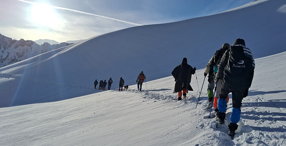
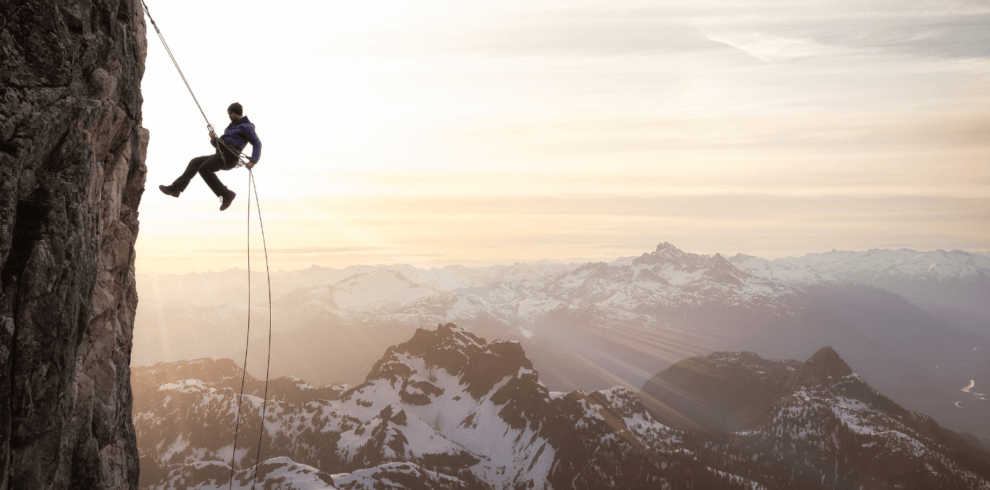
Since the conditions on high-altitude are unpredictable, there is a constant readjustment of plans to adapt to the situation at the time. Providing fixed day-wise schedules is hence tricky. But roughly, the schedule includes rotation rounds between camps which is a standard acclimatization process on high-altitude expeditions. Mt. Satopanth has 3 camps at 5,130M, 5,790M and 6,200M above the basecamp.Camp 1 (5,130M): Camp 1 lies at an altitude of 5,130M which is an approximate 250M of height gain from our base camp. We walk a narrow ridge with the Chaturangi glacier to our left and the Vasuki Parbat that feeds the Vasuki Tal that we just left behind at basecamp, to our right. This is when we get our first glimpse of the mighty Mt. Satopanth. From here we go down towards Sundar Glacier. After a fair bit of walk on a moraine-rich terrain, we reach Camp 1.Camp 2 (5,790M): Camp 2 at an elevation of 5,760M is a technical and hard climb with an altitude gain of 660M from Camp 1. The route which presents challenges in the form of alternating ice and rock patches, vertical ascents and ice gullies requires the use of a fixed rope and ascenders to make a successful ascent.Camp 3 (6,200M): At an height gain of 300M from Camp 2, the Summit Camp for Mt. Satopanth lies at an elevation of 6,200M and requires the use of a fixed rope all the way through. The most treacherous part of the climb starts once we hit the knife ridge with steep slopes on either side, post which we come face to face with the vertical ice face of the mountain. The campsite is interesting too, for its set on a hanging glacier.Summit Push (7,075M): Like all other summits, it is vital to cover as much distance as possible through the night because that’s when the ice is most stable. You start the climb between 11 and 12 in the night. Hopefully all the anxiety and tension from the physical and mental stress you put your body through the past few days, will dissolve into the calm of the night as you focus on the climb and the goal ahead. We go through the south face of the mountain. Because the gradient is not so high, we make use of fixed ropes only on certain sections of the climb. What’s more challenging, however, are the rock and boulder sections during the ascent which need you to pull your weight up massive boulders all while wearing crampons. The summit offers stunning views of the Garhwal Himalayas to the south and the Tibetan Plateau to the north. The most difficult part about the climb apart from the majestic altitude is the daunting knife ridge at 6,500M and the technical rock and glacial negotiations.Summit Camp (6,200M) to Gangotri (3,415M): We make this long journey after summit from the summit camp all the way back to Gangotri in the span of 5 days. Descends can be precarious so try to keep yourself as focused as while going up the mountain – depleted energy has a way of defocusing your mind. The thought of going towards warmer lands has a way of keeping the motivation high! We trek up till Uttarkashi and make the 100 km drive from there to Gangotri by Day 19.
Day 9 :
Depart from Uttarkashi
Your expedition ends here but not before some celebration. How can we end this adventure without a summit party?Like we indicated before, the weather on high-altitude is unpredictable as are many other conditions, we would suggest you keep spare days between the end of the expedition and your travel arrangements to head back home.